The Amazing Dredge NO.4…Along the Yukon Highway

No trip to Dawson City is complete without seeing the Amazing Dredge NO.4. This massive gold digging machine is huge even by today’s standards of big equipment. I was so impressed with this bit of our history and in particular the dredges of the Yukon. I am featuring it totally in this blog. Some of you will know the history behind it but perhaps others may not so here is my best attempt at describing the amazing Dredge NO.4 and my images of this historical machine. Thank you to Parks Canada for the input in salvaging this part of our history and the work already gone into restoring this monster machine, worth every penny of our tax dollars for sure.

GEP40029
Now a Parks Canada site.

As early as 1870 prospectors were drifting into  the Yukon in search of gold, but the discovery of Skookum Jim (Keish), Dawson Charlie (Kaa Goox), and George Carmack in the Bonanza Creek area then known as Rabbit Creek changed everything. It sparked a gold rush that would see over 40,000 hopeful gold seekers from the “outside world” rush into the Yukon making Dawson City boom and put the Yukon on the map. What started by thousands with picks and shovels would last only a few short years and by 1899 prospectors were chasing new dreams in Alaska and machines were replacing the men with pick and shovel.

GEP30149
The amazing Dredge NO.4
GEP30147
Floating 300.000 tons of timber and iron.
GEP30144
Conveyor to dispose of the tailings
GEP30140
The huge boom for the excavator buckets.
GEP30141
Massive chain link and cable to control the digging.
GEP40044
From inside the control room.
GEP40026
Just one of the buckets on the dredges main boom.
GEP30143
Rows of replacement buckets for the Dredge.

By 1905 regulations changed from individual claims to allowing larger corporate claims to dominate the Bonanza Creek and other areas and large dredges were becoming the prevalent method for mining the gold. The huge pieces required to build these machine were brought by railway and steamship and were assembled on site. It amazed me to find out these dredges were electric powered, something that would make “Justin” very happy and huge amounts of electricity came from miles away from a plant built on the north fork of the Yukon River. The demand for water was also enormous and the Yukon Ditch, a system of flumes and trenches, provided water from nearly 70 miles away. The engineering and manpower to pull this off is amazing even today.

Now for the feature presentation the amazing Dredge NO.4 it is two thirds the size of a football field in length and is eight stories high. This vessel, as it was a floating machine, inched along year after year in a pond of its own making and was the largest wooden-hull bucket dredge in North America. It dug gold bearing gravel at a rate of 22 buckets per minute. It operated 24 hours a day for approximately 200 days per season. This machine would only move half a mile per season leaving behind a massive pile of rocks forever changing the landscape of the area. Over 46 years it unearthed nine tons of gold, grossing 8.6 million dollars.

Levers everywhere to control the digging and winches to move the Dredge.
Levers everywhere in the control room to control the digging and winches to move the Dredge.
GEP40058
Massive gears and cable the main control of the Dredge.
Everything on the Dredge No.4 was huge.
GEP40042
GEP40037
A feat of engineering.
GEP40049
All powered by electricity.
GEP40050
Huge rollers in which the trommel turned.

Once in thawed ground an anchor (the spud) would be lowered to act as a pivot point. Cables attached to buried logs in the surrounding hillsides were able to control the dredge movements in the pond with winching systems on the dredge. The huge buckets on the bow dug up the gravel and deposited it into a hopper which fed the gravel to the trommel. The trommel was a constantly rotating tube with various sizes of holes along its length of 50 feet. Water was sprayed inside the trommel to wash the gravel and the gold would settle into the sluice boxes for collection. The waste gravel and rocks would exit along the stacker belt to the rear leaving tailing piles in a scalloped pattern still seen today. When it had dug to its maximum depth the anchor would be raised and the dredge move ahead approx. 10 feet filling the pond with water creating its own pond on which to float.

GEP40055
Very large electric motors powered the entire Dredge No.4 .
Huge amounts of water was moved to provide water into the trommel to was away the tailings.
Huge amounts of water was moved to provide water into the trommel to wash away the tailings.
The rotating trommel which separated dirt from gold.
A look inside the trommel and the pipe to carry water to wash the gold from the dirt.
The tailing would exit the trommel by this conveyor creating tailing pile still seen today.
The tailings would exit the trommel by this conveyor creating tailing pile still seen today.
The gold would settle to these pans which had different sizes of holes and mats. Even the gold dust was recovered by the mats.
Tailing piles from Dredge No.4.
The workshop for maintenance inside the dredge's main floor.
The workshop for maintenance inside the dredge’s main floor.
Huge timbers and Iron the bones of Dredge NO.4.

The amazing Dredge NO.4 was operated by only a crew of 4 and the shifts were 8 hours a day, 24 hours a day. The Winchmen controlled the digging and movement of the dredge. The Oiler apprenticed under the winchman and made rounds oiling the moving machinery. He was also responsible for the crew’s hot lunch. The Sterndecker was stationed at the end of the trommel and kept an eye out for blockages to the stacker belt. The Bowdecker was the rookie, standing on the bow with a shovel ensuring all dirt scooped up by the buckets was inside the buckets and not hanging out. Others were the shore crew the bullgang crew of 5 who worked outside usually in mud manoeuvring the electrical and winch cables. The Dredgemaster managed the fleet of dredges and keep all records along with the overseeing of the maintenance. In a season the dredging companies would employ approximately 750 men, in 1912 there were 13 dredges operating in the Klondike.

The Amazing Dredge NO. 4 ceased operations in Nov 1959, after sinking where it sits today. In 1991-92 Parks Canada began extensive restoration of the dredge, freeing it from 18 feet of ice, silt and mud after a dam had broken. It was refloated and now sits in its present location.

GEP30142
Parks Canada Dredge NO.4 now a historic site for all to see.

This is my brief report on our visit and tour of the NO.4 Dredge just outside of Dawson City, hope it kind of explains a bit along with the photos well worth our trip to the Yukon definitely a must see.

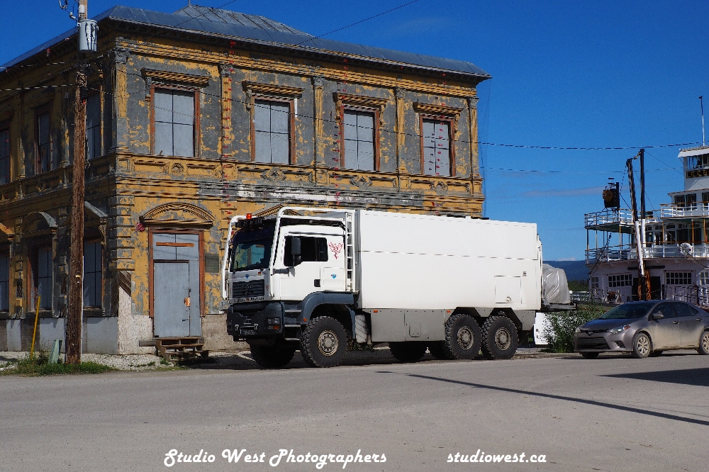
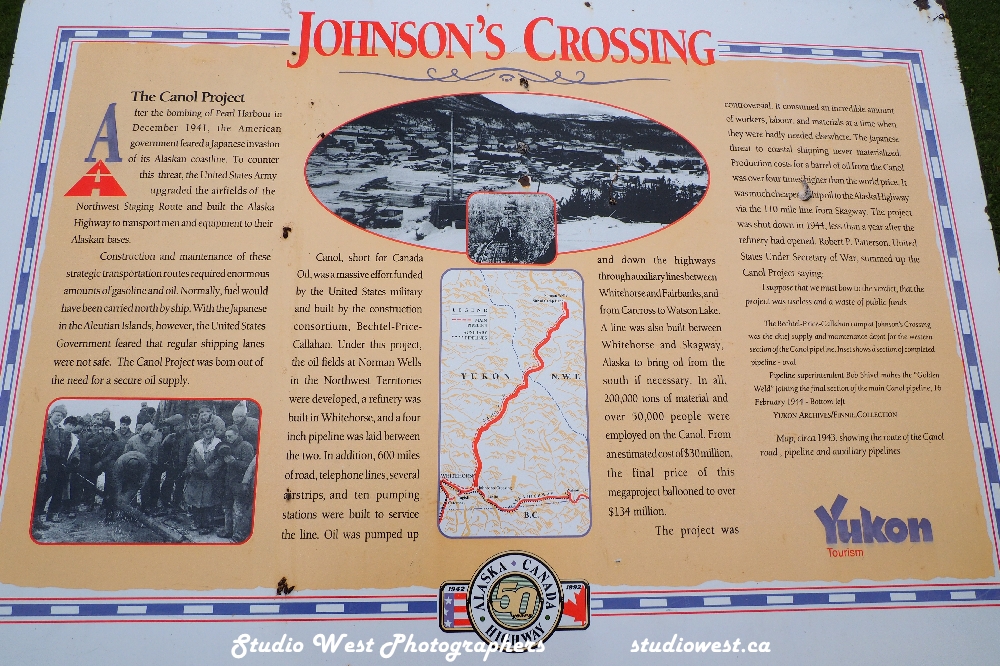
My next blog, a few more of our discoveries we found along the Yukon Highway (Klondike Highway to be exact). Trying hard to keep our family and friends updated on our travels but travel keeps getting in the way so I am running a little behind but have taken a week to sit still and hopefully catch up. We backtracked on our way to visit some special people and the great city of Yellowknife in the Northwest Territories. Thanks to those who recently subscribed to be informed of future posts by email I hope you enjoy the images and a few details of our trip. Our truck camper has been a great home and the good old Ford F350 just keeps on going…thanks and we hope to see you down the road.

Gerry and Charlotte (editor in chief).

Paddle Wheeler Graveyard…Along the Yukon Highway (6)

GEP50095
On our bucket list the Paddle Wheeler Graveyard.

Mon. July 25th. Day 22, Our goal to visit the Paddle Wheeler Graveyard. Mileage 3,834 kms, travelled only 78.7 kms today. We started our day at the Yukon River campground today with a campfire coffee this morning. To access the Yukon River campground requires crossing the Yukon River on a free ferry and is situated at the start of the Top of the World Highway to Alaska.  The campground is beautiful with around 100 sites running along a very full Yukon River and some sites are back into the forest and very quiet. It’s a Territorial campground $18 pre purchase passes or online or $20 cash at the site as in other Territorial parks in the Yukon. Just north of the campground is what is referred to as the “Paddle Wheeler Graveyard”. We were told due to the high river it may not be accessible but luck was on our side as there was a path through the bush to the site. A short hike after breakfast across several small streams one of which I dropped my camera in we found the site. The reason I went with the Olympus OMD for a travel camera is it’s suppose to be water proof, it was tested and passed. It’s hard to imagine just how big these steam powered paddle wheelers really were and now in a state of decay along the river they once travelled. We are told approx. 250 of these ships traveled the river during the gold rush days. The rest of the day was spent getting supplies needed to leave, water, propane some grocery items and fuel up.

GEP50116
The giants of the river slowly being reclaimed by the river.
GEP50122
Timbers and metal now all that remains.
GEP50120
If one could only know the stories behind these large ships of the northern rivers.
GEP50117
A lot of work required to keep these boilers fed.
GEP50084
The books could not possibly describe this scene.
GEP50099
Another check mark on the bucket list a dream come true.
GEP50113
A sad ending for these once necessary forms of transportation.
GEP50091
Only the hubs of the paddle wheels left.
GEP50115
With today’s lumber prices one of these baby’s would have cost a fortune.

A little information on the site just outside of Dawson city. The paddlewheel graveyard is tucked secretly among the spruce trees along the west bank of the Yukon River. Once considered the primary mode of transportation in the region, these boats were abandoned when ground travel became more popular. Here they were docked and now sit in decay, huge timbers and decaying wood as the river slowly claims them back. The huge smokestacks and boilers rusting in among the wooden hulls and broken paddle wheels.

Since the discovery of Klondike gold, hundreds of paddle wheelers ruled the Yukon River. These mighty ships braved harsh conditions in remote areas, supplying Dawson City, Whitehorse and Fairbanks with a diverse range of goods and services. With the addition of airplanes to its transportation network in 1937, and the construction of various highways linking Dawson City, Whitehorse, and Fairbanks, the need for boats was diminishing. In 1953 the road to Dawson was completed which marked the end of the stern wheeler’s working days. The SS Keno was the last stern wheeler to ply the Yukon River when it made its journey to Dawson City on August 26, 1960 for its final resting place. Other paddle wheelers that plied the Yukon were not so fortunate in their fate, and were dry docked on the shores of the Yukon River. The river took over and throughout the years pushed the docked ships up the bank, destroying them. We discovered at least six decayed hulls but if one searched there would be more I’m not sure exactly how many are there.

GEP50124
The trail to the graveyard watch for bears.

How to find the site: Board the George Black Ferry (landing at the north end of Front Street), and travel across the Yukon River.  Make your way to the Yukon River Campground and continue to the end of the campground, stopping at a little yellow gate. Follow the trail to the river’s shore and walk approx. 200 meters (1/8th of a mile) and then you’re there! Depending on the time of the season, you can either walk along the beach which was flooded when we were there or follow the trail in the woods. Be bear aware there was one in the campground last night which the trail starts from.

Please note that the site is unmanaged and should be explored at your own risk and left as you found it for others to see. It was definitely on my bucket list of places to see.

GEP50119
We counted six paddle wheelers here.
GEP50123
Timber and rusted iron all that’s left of their legacy on the river.
GEP40081
The giants peaceful resting place along the Yukon River they once dominated.

We are considering travelling up the Dempster Highway to Tombstone National Park. Camped tonight at Bonanza campground just outside of Dawson in a dry camp spot for $19 showers and laundry included.

GEP60001
The Bonanza Campground nothing fancy but workable.

Tues. July 26th. Day 23 Mileage 4293.3 drove 459.3 kms today more than planned. Left Dawson City this morning with the plans of going to Tombstone National Park on the Dempster but it was rainy, muddy and lots of construction on a bad road to begin with we opted to add Yellowknife NWT to our travels instead. We stayed overnight at a Territorial Park Fox Creek a beautiful spot right on the lake with water pure and clean, would highly recommend this campground, nice creek running through it, good tenting sites and could accommodate fairly large rigs. The drive today was bad, lots of construction long wait times and very rough roads through the construction and very muddy as well. We were stopped for a while for a semi that was on fire no one was hurt.

GEP60015
Not so good for this trucker along the Yukon Highway.
GEP60017
Fox Creek Territorial Park along the Yukon Highway.
GEP60034
Evening at Fox Creek very peaceful.
GEP60020
The beauty of the truck camper right on the beach in a spot too small for most.
GEP60050
Cannot resist the beauty of light and shadows with a little colour.
GEP60035
Cool clear water probably could drink it.

Wed. July 27th. Day 24 Mileage 4476.9 traveled 183.5 kms today from Fox Creek campground south of Carmacks, Yukon to Squanga campground another Territorial campground on a beautiful little lake. The trip included a stop at Whitehorse the capital of the Yukon, around 35,000 of the Yukon’s 45,000 people live there so is a very busy center and a hub to the US and Dawson city. They say there is gold in the Yukon and there still is if you can file a claim on a carwash….A wash back home that would be around $12 set me back $38.50 here. It’s a gold mine with all the construction going on and the many gravel roads you don’t see many shiny clean vehicles around here now I know why. We picked up an extra gas can for our trip across to Yellowknife and fueled up for $1.99.9/litre. It’s too bad we have to follow our tracks back but have been told by several travellers we met that #4 or the Campbell highway is very rough. We have had enough rough roads on this trip with construction everywhere. When asked where we spent our summer we can say visiting road construction sites. Rained a little today but stopped and we enjoyed a campfire.

That’s about it for this post next post our visit to the Gold mining equipment of the Yukon and Dredge #4. Actually had a few more subscribers follow along thanks for finding my ramblings and photographs interesting. Appreciate your feedback as well. It’s tough to balance spending time on the computer when surrounded by interesting people and the beauty of nature. We have met people from all over the world and it’s amazing how many ties there are to good old Saskatchewan.

Subscribe if you wish notification of posts and may the wind always be on your back while travelling. We hope to see you down the road….

Gerry and Charlotte

Dawson City…Yukon along the highway

Dawson City….Yukon along the highway part 5

GEP30166
Made it to Dawson City feel gold fever setting in.

Day 20 Mileage 3,755 kms, travelled 207 kms today from Moose Creek campground to Klondike River Campground just outside Dawson City. Today the road was narrower, lots of mountain hills and construction again in several places, slow going but that’s ok we have nothing but time. After checking in to the campsite we toured Dawson City and what can I say about Dawson City that has not been written about thousands of times. The history of this town is incredible.

GEP30112
The frontier town feel and look Dawson City.
GEP40009
Lots of accommodations for everyone.
GEP30109
The paddle wheeler played a huge part of Dawson’s growth and prosperity during the gold rush era.
GEP30095
Gold Fever!

The city is no where near as vibrant as it was in its hay day but still has the charm of a frontier mining town. I loved the old buildings, some restored and some not so much. It’s been a tough slug for the merchants of this frontier town with covid shutting down the borders for two years. The visitors to Dawson this year was again a little down due to high fuel costs, as high as $2.50/ litre we found. The other problem they face is the lack of workers in all areas from hotel work to retail sales and trades. Stores were closed either early or on the weekends because of lack of staff. I had several job offers, now that’s getting desperate.

GEP30111
Wonder if it was the western hat or she is just friendly…
GEP30110
Flora Dora Hotel
GEP30107
Gold is still in Dawson City.
GEP30104
A great grocery store with prices comparable to most urban stores.
GEP30118
Old time fiddle music during the weekend farmers market with some great produce and local crafts.
GEP40007
A lot of the original buildings are being restored.
GEP40008
Some may be beyond repair.
GEP40004
If only these walls could talk.
GEP50133
This was probably a pretty upscale cabin in its day.
GEP30122
St Andrew’s Church still standing.
GEP40011
This paddle wheeler was saved, many are in the paddle wheeler graveyard another blog to come.
GEP30133
Another being salvaged for future generations to see.

The information centre in Dawson was very helpful in directing us to what to see and do while visiting and any tours you want to take are booked there. We found out where we could find a sani dump and free potable water to fill the camper with. The lady who runs the Northwest Territories information centre is a local resident for many years and a wealth of knowledge. If you are travelling the Dempster Highway she is a must to talk to. They have a book of experiences written by those who have travelled it and survived. Dawson City was everything I had read about and now had experienced it…somethings you just don’t get from a book that real life offers.

Day 21

GEP30132
Our ride across the mighty Yukon river to our campground and the start of the Top of the World Highway.

Mileage 3816 kms, travelld only 60.7 kms today from Klondike River campground and toured Dawson City walking some more absorbing the history and culture of the community. Today we took the ferry across the Yukon to the Yukon River Territorial campground located at the start of the Top of the World Highway. We are finding the Yukon parks great as they are first come first served no reservations and they cost $20 cash or $18 when you purchase camping passes from retailers. The parks are clean well laid out nice sites and no hookups just dry camping. We noticed very little generator use in the parks as it is discouraged so everyone can enjoy the quiet found in nature. Most travellers such as us are used to “boon docking”. 

GEP40078
All of the Yukon territorial campgrounds were great, no reservations cash or prepaid pass.
GEP40001
A lot of RVS shipped from other countries full self contained like this one we saw on the road.
GEP50130
The new mode of transportation on the Yukon.
GEP40003
Very colorful business fronts in this town.

Yes today I bought a gold pan for an investment of $13 which I will never make back, perhaps a tax write off? Again we met a lot of travellers from all over the world, I would say the majority were not from Canada. Travelling by motorcycle, bike and every type of RV possible from a SUV to overland vehicles and monster overland vehicles, stuff we don’t see in Canada for sale. Lent my axe today to two young men from Victoria BC who had ridden bikes from there and were going to ride to the Arctic Ocean, I did mention they were “young” right! Another gentleman in his 70’s such as myself had been pretty much everywhere in Canada and most of the USA canoeing and staying in a tent. He was preparing to do a fly in tour and canoe to the Arctic Ocean…never say age is a factor it’s just a state of mind. When we waved goodbye he said “never quit travelling”.

GEP40021
What can you expect from a $13 dollar investment.
GEP40067
This is how it’s done today more of an investment perhaps more return.
GEP50134
The Cadillac of the north.
GEP30134
It’s good to see history so well preserved, and Dawson City is doing it. Even when there are those who feel we got to hide it and tear it down.
GEP50137
Part of our history whether we like it or not.
GEP50136
GEP50140
The Sheriff in town!

I’m going to let my photos show Dawson City and area as the history has been told it was our go to place and on that list was the Dredge #4 and the Paddle Wheeler graveyard. These will be featured separately in my upcoming blogs Dawson City was everything I read about and glad we made it here more to come.

Subscribe to be notified of future blogs and thank you to the new subscribers, it helps when one has to sit on a nice day sitting on the shores of Great Slave Lake and put thoughts to words and edit through 100’s and 100’s of images. Thanks it’s great to be able to share and we hope to see you down the road….

Gerry and Charlotte

Yukon along the highway…Whitehorse Yukon part 4

Day 18 Mileage 3209.7 we drove from Johnsons Crossing Yukon today to Lake Laberge where we camped for the evening at a Yukon campground, again only $18 pre- purchased. A great campground on the lake with nice sites, pit toilets, tables and firewood included.

GEP10047
Laberge Lake home for a night.
GEP10043
Laberge a beautiful lake along the highway
GEP10041
GEP10044
Laberge where we met a young couple from Sweden.
GEP10036
As always great campsites.

We stopped over in Whitehorse, the capital of the Yukon. A growing community, the population of Whitehorse is estimated at 42,986.  They say 75% of the Yukon population live in Whitehorse and surrounding area. Dawson City is the second largest community with a population of around 1300, all other towns have less than 1000 residents.

 Whitehorse was named for the Whitehorse Horse Rapids which before the river was dammed resembled the mane of a white horse. Whitehorse was established as a transportation hub in the building of the Alaska Highway. We visited the Yukon Travel Museum which featured a lot of the equipment in the building of the Alaska Highway and various forms of travel in the area through the ages. A very interesting and must visit museum.

GEP10012
Yukon travel museum Whitehorse.
GEP10018
A monster snow train used in the building of the Alaska Highway.

GEP10028
GEP10026
GEP10013
GEP10017
One of the Paddle Wheels of the Yukon key to moving people and supplies.
GEP10015
GEP10023
Just a lot of history almost too much to absorb comes from this area.

Situated right next to the travel museum we noticed the Yukon Beringia Interpretive Centre and took the tour. There we met Ice Age giants like the woolly mammoth and the scimitar cat that ruled ancient Beringia. We learned about this era looking at skeletal remains, and interactive exhibits and we sat through a very interesting film going back 40,000 years. I had to look up Beringia and found out it was the land mass that used to connect northwest Canada and Alaska with northeastern Siberia, Russia about 11,700 years ago, just a little before my time. Because I was not around then how could I have possibly known about this, perhaps the day I skipped school. Now we know a little more about the inhabitants of the Ice Age.

GEP10030
The Beringia center.
GEP10032
GEP10029
They did not tell us …we bought bear spray!
GEP10031
This history is even before history.
GEP10034
Yes Jeff Kwansy there really was a beaver this big.

Just pass Whitehorse we took number two highway or the Klondike Highway towards Dawson City. Whitehorse had the cheapest gas in a while at $1.999 sad when we think that is cheap.

Day 19 Mileage 3548 km. we drove 338.4 km. today. We left Lake Laberge today to Moose Creek Yukon campground at 559.9 km or 15 miles north of Stewart Crossing. It had rained all day so we drove further than planned but the rain stopped so we enjoyed a campfire then it rained during the night. A lot of road construction, one of many areas had the signs removed and we almost missed the turn off to the campground. On the way we stopped at the town of Carmack for lunch, the town of Carmack was established near a trading post established in 1893 by George Washington Carmack.  George was intending on trading furs with the natives and had discovered coal in the area but never became successful trader or coal miner. George ended up like thousands of others panning for gold and one of the Klondike’s first gold discoverers.

GEP30073
Moose Creek.
GEP30084
Miles and miles or in Canada kms and kms.
GEP30082
Along the highway.
GEP30077
A very common view this trip.
GEP20050
Carmacks there is history everywhere here.
GEP20051
A great lunch stop.

Pelly Crossing, the site of forest fire fighting efforts this summer as flames got close to the highway features a very long bridge over the Pelly River, one of many in the Yukon. Charlotte’s son Jeff was sent from Kelowna to Pelly Crossing to cook for the fire crews, we hoped to see him there. However the fires were under control and he was shipped to the interior of BC to feed the hungry fire crews there. The fires we had heard about were, as mentioned, under control and we really never experienced any smoke.

GEP20053
Pelly Crossing bridge.
GEP20061
The huge Pelly River.

That’s it for this post will share the images we were allowed to take and some along the highway. The Klondike Highway just got a lot narrower and a little rougher, they skimped on the road shoulders.

Hope to see you down the road, see what tomorrow brings…

Gerry and Charlotte

Yukon along the highway…Teslin (3)

Day 16 Mileage 2953 kms.  Travelled 259 kms from our gravel pit overnight stop to the community of Teslin, Yukon. Before the Alaska Highway was built, Teslin was a remote paddle wheeler outpost where people hunted, fished and trapped off the land. This is a very interesting Tlingit community rich in their culture and proud of their heritage.

GEP90075
Along the Alaska highway to the Yukon
GEP90072
Spectacular views through the windshield
GEP90071
Alaska highway on the way to Teslin
GEP10006
One of many 100’s of bridges in the Yukon.
GEP90101
The famous Teslin bridge one of the longest spanning bridges on the Alaska highway.

We stopped at the Heritage Center and learned a lot about the culture of their people with the help of their Elder Chief.  He said we could call him Sam. Teslin derives its name from tas’ten meaning “long sewing sinew” in the Tlingit language. It describes the 148 km or 98 mile long and narrow lake. The citizens there rely on hunting, fishing and gathering healthy foods from the land. They prize the salmon which they say navigate the longest migration run in the world to return to them each summer. Their Oral traditions, Sam told us, spoke of their people travelling from coastal Alaska inland to trade for hundreds of years. Tlingit ancestors began living permanently in the Yukon in the 1800’s.  More families arrived in the past century and they now operate as a self-governing First Nation.

GEP90104
Crossing the Teslin bridge on steel mesh.
GEP90113
Teslin Tlingit Heritage Center visit.
GEP90115
The dugout canoes still used today for celebrations and special occasions.
GEP90109
The modern dugout is actually made of fiberglass but very ornate.
GEP90111
Totem poles representing the five clans of Tlingit. Raven, Frog, Wolf, Beaver and Eagle.
GEP90114
The Raven clan totem pole.
GEP90117
The cabin of the Elder herb lady on site where living off the land is an everyday part of gathering healthy foods.
GEP90097
The beautiful Fireweed the official flower of the Yukon can be seen everywhere along the roads and in the woods of the Yukon.

From there we went to the George Johnston Museum located just off the highway and displays Tlingit native ceremonial regalia, hunting artifacts and rare local photographs taken by George Johnston, a venerated Elder (Kash Klaa). The story of George Johnston is amazing. He brought a 1928 Chevrolet by steam paddle wheeler to Teslin that had no roads and would taxi people for a dollar on a four mile road he had built. In the winter he painted it all white and drove it on the 98 mile frozen lake to hunt wolves.

GEP90118
The George Johnston museum in Teslin a must see for the history of the area and the customs.
GEP90121
The George Johnston museum as seen from the highway.
GEP90120
The history and story of a colorful character of Teslin.
GEP90124
Our home at the Teslin Lake government campground just outside of Teslin.
GEP90125
The beauty of RV travel is the folks you meet along the way. Not in order- Antoine, Laurenie, Marie and Benjamin enjoying life on the road.

The cost for the heritage center was five dollar each and the museum six dollars each, money very well spent. We even spotted a bear running across from the Heritage Center which was a bonus. Tonight we will spend at the Yukon campground just ten kilometers out of Teslin for the flat fee of $18. It’s a nice evening and firewood is supplied so will have a fire and enjoy the evening off the road. On our evening hike we met some very nice young people traveling from Montreal to Alaska in a unique truck set up with two roof top tents. We have met so many great folks on the road from all over in all sorts of different rigs from tents, roof top tents, cars, mini vans, cargo vans to big class A and overland rigs. Of course the number one method of travel is the truck camper, I may be a little biased but pull types and fifth wheels are few and far between unless they are small teardrop or off road trailers. Filled up today in Teslin for @2.03 /litre.

Day 17

Mileage 3019.6 kms. Drove only 66.6 kms today to Johnson’s Crossing. The campground there where we had internet and power. Great showers and we did laundry as that is one thing our camper lacks that the cabin has. Here we could fill up with water and has a dump station, yep in an RV when you flush that is not the end of it. Temperatures have remained around 20 to 22 celcius and dropping to our low tonight of four.  Made chili tonight, it was that kind of evening, worked on the blog and did maintenance and house cleaning. Johnsons Crossing is known for its  famous cinnamon buns. While we were there a number of Class A motor homes were stopping in for the buns. They had called ahead and warned the owners to have them ready, at least 24 in the group all Americans heading to Alaska. As in the north I cannot stress enough about having cash available. The couple who run the shop said the internet is very unstable and although we used it to pay our $37 camp fee, the next morning it was down when we wanted to purchase Yukon camp passes. Also fuel up when you can, his fuel shipment was late coming and was out of gas and diesel. Great couple, a very basic campsite at the end of a very high, long bridge. When I asked if the name Johnsons Crossing came from the George Johnston from Teslin, he said no, probably not, could have been some American general or something he was not sure. He did tell me though he believed the elder native woman from the area that said it was because the first ferry across the river had two Johnson motors, so let’s go with that.

GEP90078
The beautiful hike into the Rancheria Falls along the highway to Johnsons Crossing.
GEP90081
Tier one of the Rancheria Falls.
GEP90079
The beautiful forest surrounding the falls.
GEP90080
Tier two of the falls.
GEP90083
Rushing rivers everywhere in the Yukon.
GEP90087
Rancheria Falls a must stop.
GEP90084
Clear running water as the melt in the mountains continue late this year.
GEP00130
The bridge to Johnsons Crossing.
GEP00126
Another long span and high bridge of the Yukon.
GEP10001
This doesn’t mention the famous cinnamon buns available here.
GEP10005
On the road again see what tomorrow brings our way.

Ok going to sign off tomorrow we will head to Whitehorse and stock up on supplies. Glad you are interested enough to follow along gives me a reason to keep showing and sharing this beautiful land, its cultures and people who live here. Subscribe if so inclined to be notified when I can get internet to get this trip posted… stay safe and we hope to see you down the road….

Gerry and Charlotte

Yukon along the highway…part 2

GEP50006 1
The Alaska highway is in excellent shape so far as we head for the Yukon.

Day 11 on our way to the Yukon, mileage 1701 a very nice sunny day around 20 celsius but again windy we headed into Fort St John for the day as Char had to be in cell range for a important call. We found it very hard to find anyone that topped up propane tank in town finally found co-op service stations did. The other stations wanted $34 for exchange I topped up for $15. Fuel today was 2.02 per litre. We stayed at Walmart and met a really nice chap from Texas who lives in his van and delivers parts all over North America. He was delivering a John Deere engine to a dealer in Fort St John. We met another couple from Wisconsin that were on their way back from driving the Dempster highway and did not have good luck, they cracked two rims. On the way back they had to camp on the highway for 20 hours with others as the fires shut down the roads. We were informed then the forest fires were starting to get under control they said 5,000 lightning strikes had been recorded in one day. This was good news to us as only two weeks ago they were advising non unessential travel to the Yukon.

GEP50018 1
Beaver Lake campground free.

Day 12 Mileage 2124.7 km we traveled 423.5 km today from Fort St John to Beaver Lake just west of Fort Nelson. The campgrounds were packed at Fort Nelson as an Airstream tour was booked there as well as a large motor coach tour. We were happy when we found Beaver Lake forest service campground at no charge with picnic tables and fire rings. Scrounged firewood and cut some from dead trees in the surrounding forest. Met a young couple who pulled in after us in a Land Rover they had shipped from France to Halifax. They have been on the road 2.5 months and plan on a canoe trip in the north before continuing their travels for the next two years. Filled up today for $2.18/litre.

GEP50021 1

Supper on the go after cutting and splitting firewood at Beaver Lake.

Day 13 Mileage 2357km travelled 232.3 km today from Beaver Lake to Muncho Lake through the highest pass on the Alaskan highway at 4,250 feet. a lot of construction in this area and some wait times slow going but not bad. Char said the scenery was beautiful from that high up, I was watching the road so will take her word for it. Filled up at Toad River for $2.39 /litre the highest on the trip so far. Muncho Lake is a beautiful jade color and very cold. We were lucky to get the last campsite on the lake as we pulled in early today. The highway runs along side the lake cut out of the side of a mountain and we are told it was the most expensive part of the Alaska highway to be built. Equipment was lost to the very deep lake around 300 feet deep as all the rock had to be hauled away as they carved out the base. It was a very beautiful spot to unwind after the drive through the summit.

GEP70061 1
Muncho Lake.
GEP70060 1
The view from our campsite.
GEP60054 1
With all sites along the lake this is a very popular campsite.
GEP60050 1
Still snow in the mountains at Muncho Lake.
GEP60047 1
Leaving Muncho Lake continuing to the Yukon.

Day 14 Mileage 2412km a light travel day today from Muncho Lake to Laird Hot Spring only 64 kms. A very popular spot along the highway, we checked in early, there is no power sites or services here just dry camping. We paid $27 and that included our pass into the hot springs that were $5 each. Again firewood was $15 for a small bundle. The mosquitoes were BAD! Not in the hot springs but at the check in and campground. Even the workers were wearing nets. While in the hot springs we met people from all over some travelling full time and others just for a spell. No outside tonight I worked on the blog and Char organized clothes which again we brought more than we need. No internet service and again cash only.

GEP70005 1
Looking forward to a dip in the hot springs we made it to the famous springs.
GEP70094
An electric fence around the campground helps separate the humans and the bears in the area.
GEP70079
An overview of the springs.
GEP70092
At one end the water is very hot it overflows into a cooler area.
GEP70075
A board walk connects the campground to the springs about a ten minute walk.
GEP70072 1
From the walkway to the hot springs wildlife can be spotted and one has to be Bear Aware.
GEP70081
The Hanging Gardens at the hot springs is a must see.
GEP70088
The terraced hill side features the hanging flowers and plants all done by nature.
GEP70089
Nature, naturally in all its beauty.
GEP70004 1
Just outside of the gates at the hot springs these buffalo were dusting from the mosquitoes.

Day 15 Mileage 2675 km filled up at Contact Creek for $2.15 litre. Lots of up and down mountains again on the way to Watson Lake and the sign post village. Watson is a very friendly RV town we got a free dump and free potable water here. The sign post village is just something one has to experience it is hard to explain the over 100,000 signs by the looks of the a lot were stolen from communities around the world. We left our small sign there to document our passing that way. We checked out the museum and watched a movie on the building of the Alaskan Highway. We were able to pick up our Yukon Territory passes for camping at Watson they are $18 each a little saving as at the sites it is $20 cash only. We are finding the Territorial campsite quite nice they have tables and fire rings and pit toilets. The camp site Gold Nugget was $75 US per night we passed on that and further down the road found a nice secluded gravel pit away from the highway for zero down and zero per night. Took a hike and had a small campfire in a very quiet spot now can’t beat that.

GEP80021
Made it this far.
GEP80048
Watson Yukon famous sign post forest.
GEP80035
Thanks to a couple of American bikers we had a photo of the two of us.
GEP80041
Leaving our little sign amongst 100,000 other signs.
GEP80042
Just to show we passed this way.
GEP80052
Some of the early equipment used in building the highway.
GEP80051
The entire highway built using this equipment in less time then it would take us to do an environmental study today.
GEP80057
Our quiet beautiful gravel pit campsite just out of Watson.
GEP80065
A visitor to our gravel pit campsite.
GEP50011 1
Another free campsite along the way.
GEP50008 1
Bucking Horse River campground.
GEP80022
Along the way.
GEP80010
A great stop and hike into this water fall in the Laird Canyon.
GEP80009
One hike two falls a bonus!
GEP80018
Feeding time along the highway.
GEP60034 3
Highest pass on the Alaska highway.
GEP60029 3
Stops along the way.
GEP50014 1
As far as the eye can see.

Well I know right now I will not spoil anyone’s future trip here by showing my images as they cannot even capture the vastness of the land and its beauty. There is a depth to the beauty that my camera cannot capture one just has to see it for themselves… We will continue this journey at the next cell coverage

Hope to see you down the road…..Watch for the studiowest.ca Northern Lite

Gerry and Charlotte

Yukon along the highway

You're supposed to be able to control the camera from the phone...it worked
You’re supposed to be able to control the camera from the phone…it worked a selfie before leaving our cabin
The road begins to the Yukon
The road begins to the Yukon and now perhaps the Northwest Territories

A little report from the front lines in the battle of high fuel prices and RV travel to the Yukon. It’s now day 10 we were a little side tracked which is what the trip is about…getting sidetracked and enjoying the journey. We visited Elk Island National Park on the way to Edmonton, hopefully we can stop on our return trip as we have yet to canoe that lake. Night one was spent at St. Albert Walmart, not an easy one to get to, that’s probably why we were the only ones in the lot that night (thank you Walmart). After this trip to the Yukon we will probably not be able to sleep without the lulling sound of semi’s and jacked up half tons with the original exhaust removed and noisemakers added for maximum effect. Our little cabin is way too quiet.

GEP40018
Elk Island National Park just east of Edmonton, Alberta.
GEP40012
These boys rule Elk Island.

Day two we arrived in Hythe, Alberta stopping at Hythe campground. Oour apps informed us it would cost $20 without services. This was great as we did not need any services. We were informed that we had to take them and the cost would be $52.50. We naturally left this campground. It is right along the main highway to the Yukon and very noisy. Searching on iOverlander we found a campground at Spring Lake 26 km away on a forest service road. It is located beside a small lake, no power boats allowed, nestled in the forest away and quiet, a beautiful well kept campground. Sites featured no power or water but a picnic table and firepit, wood supplied in the cost of $27. We would go back and spend more time there for sure.

GEP60029
Home at Spring Lake recreation camp spot.
GEP60034 1
Spring Lake, small but beautiful.
GEP60032
No power boats allowed on Spring Lake fish are primarily trout.

Day three we arrived at a friend’s farm near there and joined a few friends for the next four days. A peaceful, enjoyable stay. While we were there we were told about an area to the south of us called Tumbler Ridge Global Geo Park. News reports coming from the Yukon at that time said travel not recommended due to the large number of forest fires close to the highways. Our son, a cook for camps, was flown from Kelowna to Pelly Crossing to cook for the fire crews. He beat us to the Yukon and had not even planned to be there. The washout of the main highway was detoured and traffic was moving again so we thought perhaps we would play in northern BC for awhile then head north.

Day 7, Sunday afternoon we travelled to Dawson Creek, BC Mile Zero of the Alaska highway and again where we spent the night at the local Walmart. That evening friends who we met at the farm Jess, Tanis and Josh joined us for a surprise visit bringing Ice Cream from Walmart of course.

GEP10042
Great scenery at Dawson Creek Walmart where you meet the nicest people from all over.
GEP10055
Mile Zero with our friends Jess and Tanis our guides for the day.
GEP10067
Typical tourist photo.
GEP10070
The only original actual mile marker marking the starting point of the Alaska Hwy.
GEP10060
The surveyor.

Day 8, the next evening we had reservations at Mile Zero campground in Dawson Creek, time to shower up, dump tanks and fill with water. Great campground. We camped in overflow or tenting area with a large number of groups travelling by motorcycle and some in overland vehicles. Would recommend this park without services picnic tables only but use of the showers and dump site included $27. We toured Dawson city visited the gallery and visitors center.

GEP10058
Jess, Charlotte and Tanis Dawson Creek museum, gallery and information center.

Day 9, mileage 1459 km left Dawson Creek on Highway 59 south to Tumbler Ridge 168 km away. Tumbler Ridge is set in the mountains and is a mini Banff or Jasper with many services and the usual tourist stuff. The park is billed as a Global Geo Park. Geoparks are specially designated places that are recognized for their international geological significance by UNESCO ( United Nations Educational, Scientific, and Cultural Organizations). The 34 accessible geosites include mountain peaks, alpine meadows, glaciers, canyons, waterfalls, caves, karst formations dinosaur trackways and fossils. Also within the park boundaries are wind farms, mines and forestry operations. No matter what outdoor recreation you’re into from mountain climbing to snowmobile or ATV or less motorized travel the park has it all. We realized it would require many more days to properly explore this park and we were not set up for the hikes so it is on our bucket list as a must try and get back to, perhaps on our return.

GEP20022
Tumbler Ridge.
GEP20044
Many wind farms located in the mountains around the Tumbler Ridge area.
GEP10080
When we backtracked from Dawson Creek to do the Tumbler Ridge loop we came to Pouce Coupe community that featured this curved train trestle built completely of wood in 1930 for the Northern Alberta Railway. It is located just south of Pouce Coupe very neat.
GEP10073
Pouce Coupe wooden trestle railway bridge.

Again there is a lot of history here we checked out many sites along highway 29 to Gwillim Lake Provincial Park situated as the name suggest on Gwillim Lake. The sites were as most of BC’s provincial parks clean spacious and offered no hook up services. As most of BC’s provincial parks and why we like them there are no reservations, its first come first served, $20 per night cash only as there is usually not internet service. The bears at Gwillim were an added feature if you don’t mind bears. Would also definitely recommend this park. We enjoyed a campfire in our campsite overlooking the lake and debated spending another day there to do some kayaking, however the winds were even stronger the next morning and the lake was rough.

GEP20024
Home at Gwillim Lake for the night.
GEP20032
Many beautiful hiking trails takes you back to nature.
GEP20042
They grow the trees big here lots of firewood, however in BC surrounded by trees you have to buy firewood ranging from ten to fifteen dollars Canadian cash only.

Day 10, 1665.9 km traveled left Gwillim Lake for Charlie Lake through 374 km of very beautiful and extremely hilly mountain roads in the Peace River country. Saw the Peace River Dam and the extensive 2.6 km berm they are constructing along with dozens of very high long bridges. Visited Hudson Hope museum, a very nice community in the valley. The old Ford did very well in the high steep climbs and deep descents very impressed with our 6.2 gas. One thing to remember when travelling this highway and these areas a lot of time it is cash only.

GEP30058
Peace River Dam near Hope BC.
GEP30053
Bridge at Peace River Dam.
GEP30056
There are many places one can camp for the night free in BC this was a lunch stop at one near the Peace River Dam.
GEP30066
A trappers cabin we would now consider a tiny home at Hope BC.
GEP30063
Love the history of our North it’s everywhere if you look.
GEP30067
Typical trappers set up in the north with the food stored high in the air to protect it from wolves and bears and wild animals.

GEP30070
Inside a typical pioneer log cabin a step up from the trappers cabins still small by todays standards.
GEP30074
An old steam winch information below.
GEP30075
GEP30078
New passive Dam construction in the Peace River valley.

Ten days of our travels is enough to burden one with so will leave it there with a few images. Subscribe to be notified of posts and we look forward to seeing you down the road in the studiowest.ca Northern Lite. Lots of truck campers in this country, we are not unique here.

Yukon bound…we are on our way

The road begins to the Yukon

Our dream of visiting the Yukon is close to day one in our travels. That means the update on Douglas Provincial Park in southern Saskatchewan, Canada will be put on hold. Despite high fuel costs we have decided to go anyway as we would probably spend as much trying to amuse ourselves seeing the same old thing staying here in Saskatchewan.

The trip has been in the works for three years now and due to one reason or another has not materialized so it’s go time on a budget that if we can do it anyone can. We really are looking forward to the challenge we have no set time, no place we have to be, with our Northern Lite truck camper we can just pick up and move home when we want. We can spend one month or three months as our little cabin back home is looked after by a very dear friend for however long we choose to stay.

You're supposed to be able to control the camera from the phone...it worked
You’re supposed to be able to control the camera from the phone…it worked

We are told by many the Yukon is fantastic and the trip will be well worth it, we appreciate the help of our fellow travellers who have shared some neat places to visit. Places off the grid and away from the tourist traps, places we may want to hang our hats and put out the mats for a little while. At this point our plans to visit Alaska are being put on hold. The Yukon has way too much to offer to rush our visit and cover too much territory in one visit. For us it’s not all about a destination (Dawson City) it’s about the journey and the beauty along the way. If I wanted to be run by the clock and calendar I would get a job…may have to along the way if fuel gets any higher.

I really am glad I traded the Dodge diesel off in favour of our gas engine now as diesel is more costly and may even get harder to find. With the high cost of fuel we will try and offset it by being creative where we stay, definitely not the 5 star campgrounds that have raised their rates due to covid and the popularity of RV travel. For those who have just joined the blog or do not know us we are totally self-contained in our 2017 four-season 9.6 Northern Lite truck camper. We have 100 watts solar on the roof and a 100 watt portable panel. We also installed a DC to DC charger, 2000 watt generator and two 6 volt 100 amp batteries. The truck is a Ford F350 4×4 SRW with stable blocks top and lower and factory sway bar. We have rear locking differential and 10,000 lb winch to get us out of most trouble spots (failing that we have a Spot X satellite phone for HELP). Also being only 22 feet this allows us a variety of areas to camp or spend the night.

That’s why we appreciate the experience of those who have made the trip with tips and places to stay and experience. There are a number of ways to contact us with information, the best probably being our email address, gerry@studiowest.ca or the blog comments section. We hope we can meet those who also are making the trip and love to hear from all you who we can share our trip photos and experiences with along the way. So if you want to see if we can do it on a buck ten and a prayer follow along, we will be glad to have you.

If you spot us along the way stop and say hi love to hear about your travels
Our home address for the summer

OK time to finish packing and in a truck camper one has to be the “master of compaction”. May you all enjoy your travels this summer and may the wind always be in your back. See you down the road….

Gerry and Charlotte

Danielson Provincial Park

Leaving Saskatoon, Saskatchewan and heading south we arrived at Danielson Provincial Park, it was early in the season just after the long weekend in May and we liked what we found. On the way down just north of the Danielson Provincial Park is the Gardner Dam, the world’s largest earth-filled dam creating Lake Diefenbaker on which the park is situated. We stopped at the Gardner Dam Visitor Centre for lunch, it features a beach and picnic area, no camping or overnight stays.

Gardner power station.
Gardner power station on Lake Diefenbaker.
Gardner power station located at the north end of Lake Diefenbaker.
The spillway that releases water down the South Saskatchewan river.
At the spillway one can see just how low the water level is down, but at this writing they are rising.

Danielson has three camping loops, with, I would guess 300 sites plus and overflow area. Most sites are well treed and have power and water. The sewer dumps are new and very functional. The campsites can handle both small rigs and larger units in all loops. We found the sites well groomed and a very clean campgrounds. As it was early and we did not require power we opted to stay in the overflow area just off the lake. There are approximately 12 sites with fire pits and washroom with flush toilets. Potable water and a great view of the lake with sandy beach cost $20 per night. Regular spots run $33 with 15/30 amp power.

Overflow camping along the lake.
Breakfast at the overflow  site .
Breakfast at the overflow site .
A quiet peaceful evening all alone watching the evening sky change.
The sky did change many times that evening.

The lake was very low when we were there but as I write this blog the lake is starting to rise due to the rains and mountain run off finally starting in BC. There is an excellent paved boat launch which gets you onto Lake Diefenbaker, a huge lake with good fishing and water sports as described in my former article on Elbow.

When we were there the dock and boat launch were a great distance from water.
Lots of beach even at the deep end of the buoys.
A lot of water required but on its way.

Danielson is home to two major hiking and biking trails one being the Trans Canada Trail and the other the Prairie View Nature Trail. The latter forms a loop which starts and returns to the park. We hiked a section of the Trans Canada Trail which follows the shoreline of Lake Diefenbaker.

Miles of shoreline to hike and explore.
more of the shoreline at low water.
More of the shoreline at low water.
Making the best of even low water did not dissuade this person or fishermen along the shore.

The Beach Side Pavilion is a small confectionary and burger/fries take out restaurant. The Pavilion is located right off the beach area that has lots of sandy shore line. Again we were there when the water was very low but can see it features a great swimming area and day picnic area as well. We hiked a long way along the expanded shoreline due to low water and could see the high dunes of sand pushed up when the lake is full and rough.

A large lake attracts large boats.
Char looks so tiny.
Char looks so tiny.
complete with a spare on top.
Complete with a spare on top.
Out the backdoor.
Out the backdoor.
We love where our Northern Lite can take us.
A common prairie visitor.
Picture perfect!
Picture perfect!!
Where we can drive it we can park it.

Danielson is open all year round with camping available from the May long weekend to Labour Day. Danielson is located at 51.25167* N.long -106.8692*W and is accessible by good paved highway suitable for all size rigs.

the well kept groomed trails.
The well kept groomed trails.

We did a little side trip to the Coldwell Recreation Site which was not open yet so we hiked in and found a small secluded group of about 30 non power small sites. These sites are well treed and with turns that any RV over 20 feet should not attempt as posted outside the camp area. Non potable water is available and did not see a dump site. The sites are available on a first come first serve basis. We were told some long weekends the campsites are full. The area also features tables and firepits for day use picnics. It’s a neat little rustic campground located in the South Saskatchewan River Valley and not really all that close to water. The rustic, away from it all, kinda appeals to our style of camping for a few days…perhaps we will when it’s open some day.

Land of the living skies.

We found Danielson a great park to camp in and enjoy a big lake, we visited our southern parks in early and off season so have no idea what booking a site might entail during summer season, best check. In my humble opinion we need more sites that are first come and not reservable it’s hard to plan any length of stay when most sites are booked weekends only and you have no place to go…no Walmarts in the area. Or a least making sure booked sites are actually occupied and if not used a no charge cancellation policy if cancelled well in advance…just saying.

We have never stayed at the the other provincial park located on Lake Diefenbaker so we pushed on to Douglas Provincial Park, our impressions of that in my next posting. This trip, due to the fuel costs, we decided to take the back roads slow down and enjoy the trip the bonus was we saw lots of great country, I could look around while driving as we met very few vehicles and we got great gas mileage as compared to the major highways. Lesson learned: Enjoy the journey as the destination will arrive quickly enough. We all should have a destination in mind, but we are truly blessed when we can enjoy the beauty in getting there.

Right now we are back at the cabin saving our pennies so we can afford some fuel to hopefully get us to Dawson City in the Yukon starting beginning of July. While away our cabin will be well cared for by a dear friend. We will bring you along on that trip as well. Since fuel is so expensive we will be looking to doing a lot of boondocking and not staying at five star campgrounds regularly. This should be a learning experience. I told a friend we may have to eat road kill and pick pop bottles along the way he said as long as the road kill is fresh we should be OK. According to my trusty partner that will NOT happen I will be getting a job along the way… and she is emailing my resume to businesses along the Alaska highway.

down thr road to Douglas Provincial Park.
Down the road to Douglas Provincial Park.

Thanks to those who subscribe it saves me from always having to post to Facebook and Instagram as it notifies you automatically when I do post. It also gives me more incentive to keep taking, editing and sharing our travels in this beautiful country. Not all campgrounds are created equal so will keep you posted on that as well.

Take care thanks to those who tuned in may the wind always be on you back…. watch for us studiowest.ca in our Northern Lite as we hope to meet you down the road….Charlotte and Gerry

Lake Diefenbaker…Elbow

Lake Diefenbaker 2022….just add water. It’s been a number of years since visiting the lake community of Elbow, Saskatchewan situated on Lake Diefenbaker. I really don’t know where to start, the lack of water in Lake Diefenbaker or the building boom in Elbow. OK positives first, for years, 10 to be exact, the rodeo committee in Elbow hired Charlotte and myself to photograph their rodeo events for them. At the time we were professionally doing rodeo photography and being at many different events always found Elbow our favourite rodeo. I know we were paid to say that….not really, Kevin Volmar and his crew were the best we have ever worked with and treated us good year after year, we also like the small community of Elbow. Fast forward several years and we found we were in for a surprise.

Mainstreet Elbow features the cabin of yesteryear
Mainstreet Elbow features the cabin of yesteryear a little contrast to the new developments.

I hardly recognized the community when driving in, new cabins/homes, new streets numbering in the dozens where there were none before and empty stores now with tourist/lake business in most spaces. RV parks expanded into streets and avenues in several locations. Pulling over on main street I talked to an elderly gentleman who lives in town, I asked him if they found gold in the area that created all the growth to which he answered “no Covid did”. Since 2019 I would say the town has doubled in size, and some say Covid hurt the economy….well not in Elbow. If one is going to work from home why not the lake, it appears this is the case.

For those not familiar with Elbow it’s situated halfway between Regina and Saskatoon on Highway 19. Elbow got its name from a bend in the south Saskatchewan River that reassembled an elbow. Elbow is now situated on Lake Diefenbaker and features a first class marina, golf course, miles of beaches and the sailing club. The lake is 225 km long with 800 km of shoreline so very attractive to larger boats and sailboats. I’m told fishing is excellent. Danielson Provincial Park and Douglas Provincial Park are also located on the lake. The lake was created when the river was dammed up for the Gardner River Power Plant. This trip Charlotte and I visited and stayed at both Provincial Parks which I will feature in the next blogs.

Monument at the Elbow Marina overlooking Lake Diefenbaker
Monument at the Elbow Marina overlooking Lake Diefenbaker.
Twin Monument's made from the sacred rock
Twin Monuments made from the sacred rock on Lake Diefenbaker at Elbow Marina.

As mentioned the Marina is home to probably the biggest number of sailboats for sure on the prairies. Charlotte and I were lucky enough to visit with the owners of the Elbow Harbour Marina, Trish and Jake. Although early in the season they said the lake was the lowest it has been in 20 years. People familiar with Lake Diefenbaker know the levels vary over the season and count on the spring runoff from the mountains to refresh the lake levels every year. Well this year its appears runoff is later than normal and the lake is lower than normal. Boats that normally are going in are still on shore. One gentleman who we met and lives on his cabin cruiser in the summer and some of the other boaters remain optimistic it’s only a matter of time and the lake will rise. The lake has been known to vary by approximately 20 feet so it has a lot of water needed.

Lakeshore Harbor Marina Elbow early May 22
Lakeshore Harbor Marina Elbow early May 22.
Lake Diefenbaker just add water
Lake Diefenbaker – just add water.
Early in the season and low water the many slips and docking system awaits completion
Early in the season and low water the many slips and docking system awaits completion.
The Marina now stocks RV parts for us land yacht types
The Marina now stocks RV parts for us land yacht types.

By the way for you RV types the Marina is not just for marine types, it’s also set up for those who travel and live in our land yachts. They have a very good stock of RV parts as well so if in need of parts near Elbow check them out the prices are good as well.

Northern Lite with our little boat.
Just dreaming I would probably be over my GVWR anyway.
This fine craft is more in my budget
This fine craft is more in my budget.
My Land yacht parked next to its sea worthy cousins
My land yacht parked next to its sea worthy cousins.
Got to add this to my ever expanding bucket list
Got to add this to my ever expanding bucket list. Looks like it might fly.
GEP60126
Sailboats of every make and model await launch.
Waiting patiently to be launched
Waiting patiently to be launched, summer home to many.
Majestic what else can be said
Majestic, what else can be said.
come June this will look like the starting line of the Daytona 500
Come June this will look like the starting line of the Daytona 500.
A quiet breakfast overlooking the Marina and Lake Diefenbaker
A quiet breakfast overlooking the Marina and Lake Diefenbaker .
The color on the dock poles gives you an indication just how low the water is
The colour on the dock poles gives you an indication just how low the water is.
Just liked this image
Just liked this image.
For sure the beauty of this marina is unlike anything else in Saskatchewan
For sure the beauty of this marina is unlike anything else in Saskatchewan.
For sure the beauty of this marina is unlike anything else in Saskatchewan
For sure the beauty of this marina is unlike anything else in Saskatchewan.
Always well groomed and kept when it greens up for summer very beautiful
Always well groomed and kept when it greens up for summer, very beautiful.
Harbor patrol
Harbor patrol.

This makes me wonder if the Northern Lite will float they say they are built like a boat... so peaceful
This makes me wonder if the Northern Lite will float. They say they are built like a boat… so peaceful.
Getting ready for launch takes a lot of prep work
Getting ready for launch takes a lot of prep work.
No shortage of beach this early in the season
No shortage of beach this early in the season.
A new friend and his companion spend their summer living on this cruiser, at home on the water
A new friend and his companion spend their summer living on this cruiser, at home on the water.
Also at home at the marina these Purple Martins prefer condo life
Also at home at the marina these Purple Martins prefer condo life.
The "Martins" condo's
The “Martins” condos .

Signs signs everywhere mark the hiking trails
Signs signs everywhere mark the hiking trails.
For the hiker no shortage of trails here starting at Tuffs Bay
For the hiker no shortage of trails here starting at Tufts Bay.

Just a little on Lake Diefenbaker and the boom community of Elbow, worth a trip to check it out just north of Number 1 highway and south of the Yellow Head highway. Highway 19 is in great shape and a nice drive from Elbow to Saskatoon right by the door of the Whitecap Casino.

Until next post on our visit to two provincial parks, take time to enjoy the beauty around us, drive safe and with these fuel prices may the wind always be on your back. Thanks to those who have taken the plunge and subscribed it gives this old guy something to write about and share some images.

Hope to see you down the road….studiowest.ca

Charlotte and Gerry